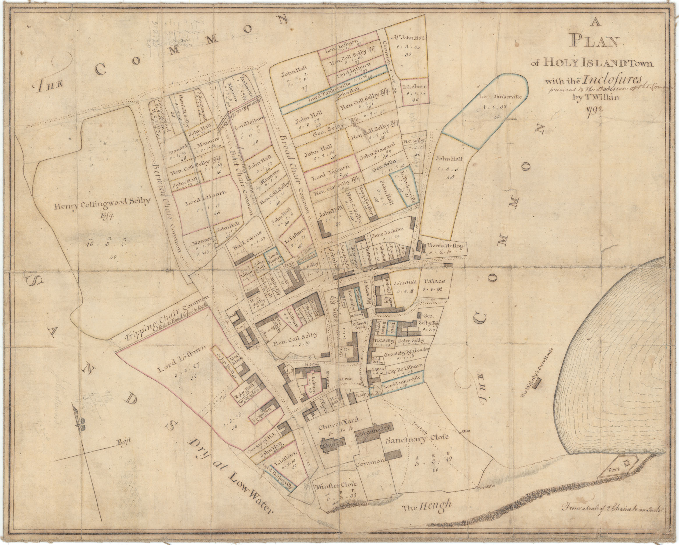
Copies of Plans and Ordnance Survey Maps of Holy Island zoomPlan of Holy Island with [ancient] Enclosures; Previous to the Enclosure of the Common. 1792Plans from 1792 and 1850, and 4 O.S. Maps 1860s-1966Date of creation 1792-1966 Date of coverage 1792-1966 Extent 6 plans/maps Place Holy Island, Northumberland Copyright Berwick Record Office Reference number HOL/042 Storage location Holy Island Reading Room Format Maps and Plans (21) Subject Farming (30)Holy Island buildings (80)Holy Island property ownership (98)Holy Island Ruins & Churches (16)Life on Holy Island (172)Lifeboats (153) Plan of Holy Island with the [ancient] Enclosures, previous to the Enclosure of the Common. (HOL/042/001) Holy Island Tithe Award Plan (HOL/042/002) O.S. Map of Holy Island. 1st Edition (HOL/042/003) OS. Map of Holy Island. 2nd Edition (HOL/042/004) O.S. Map of Holy Island. 3rd Edition (HOL/042/005) O.S. Map of Holy Island (HOL/042/006) No CommentsStart the ball rolling by posting a comment on this page! Add a comment about this pageYour email address will not be published. Required fields are marked *Your comment:Name * Email * I consent to my name and e-mail address being stored along with this comment, and to the website editors communicating with me by e-mail about the comment if necessary. My name may be published alongside the comment on the website, but my e-mail address will not be published. My information will not be shared with any third party (see our Privacy Statement - opens in a new window). * Δ Browse this collectionHoly IslandCopies of Plans and Ordnance Survey Maps of Holy IslandPlan of Holy Island with the [ancient] Enclosures, previous to the Enclosure of the Common.Holy Island Tithe Award PlanO.S. Map of Holy Island. 1st EditionOS. Map of Holy Island. 2nd EditionO.S. Map of Holy Island. 3rd EditionO.S. Map of Holy Island Search the archiveText searchDate searchList of subjectsList of formatsShare thisFacebookPinterestTwitterLinkedin
![Plan of Holy Island with [ancient] Enclosures; Previous to the Enclosure of the Common. 1792](https://www.islandshirearchives.org.uk/wp-content/uploads/2018/12/NRO-0683-09-01-FULL-SHEET-LOW-RES-768x617.jpg "NRO 0683-09-01 (FULL SHEET) LOW RES")


No Comments
Add a comment about this page